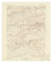
California (Nevada County), Banner Hill quadrangle.
Item Overview
- Title
- California (Nevada County), Banner Hill quadrangle.
- Alternative title
- Banner Hill quadrangle
- Creator
- Geological Survey (U.S.).
- Date Created
- 1937
- Place of Origin
-
[Washington]
dcu - Publisher
- U.S. Geological Survey, Dept. of the Interior
- Language
- English
- Collection
- Henry J. Bruman Map Collection
Notes
- Description
-
Relief represented by contours.
Title in lower right: Banner Hill, Calif.
Text and ill. on verso.
Surveyed in 1892.
Contour interval 20 feet.
Shows mines. - Note
- Ed. of July 1903, repr. 1937.
Physical Description
- Extent
- 1 map : col. ; 45 x 34 cm.
Keywords
- Genre
- map
- Location
-
California
Nevada County (Calif.)
Nevada County - Resource type
- cartographic
- Subjects
-
Mines and mineral resources--California--Nevada County--Maps
Nevada County (Calif.)--Maps
Find This Item
- Repository
- University of California, Los Angeles. Library. Henry J. Bruman Map Collection
- ARK
- ark:/21198/zz002b0fjs
- Opac url
- https://search.library.ucla.edu/permalink/01UCS_LAL/17p22dp/alma9966451323606533
- Manifest url
-

Access Condition
- Rights statement
- pd_usfed